
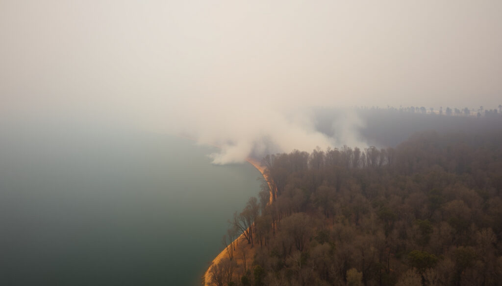
A grass fire near Enoggera Reservoir and Camp Mountain triggered a major emergency response approximately 40 minutes northwest of Brisbane on September 20, 2025. Queensland Police were called just after 2pm following reports of a fire at Camp Mountain, prompting authorities to declare an emergency zone under the Public Safety Preservation Act.
The blaze spread through dry bushland with strong winds fanning the flames dangerously close to residential properties. Multiple homes were evacuated as water bombers were deployed to assist ground crews battling the fire. Authorities established exclusion zones across a wide area including the Mount Nebo Road intersection at Camp Mountain Road, stretching west to South Boundary Road, north to Betts Road, and east and southeast to Upper Camp Mountain Road.
What is the latest update on the Enoggera Reservoir fire?
Current incident information can be accessed through the Queensland Fire Department’s Current Incidents map, which provides real-time updates extracted from their Computer Aided Dispatch database. Firefighters have been working to contain the blaze near Betts Road and Mount Nebo Road areas. The situation remains active as crews continue monitoring and managing fire activity in the region.
Active fire with containment efforts underway
Mount Nebo Rd, Betts Rd, Enoggera Reservoir area
Advice/Watch & Act status
September-October 2025
The fire started on September 20, 2025, near Enoggera Reservoir and Camp Mountain. Authorities declared an emergency zone under the Public Safety Preservation Act, establishing wide exclusion zones that included intersections from Mount Nebo Road through to Upper Camp Mountain Road.
Fire Behavior and Conditions
The fire spread through dry bushland with strong winds pushing flames dangerously close to residential properties. As the flames broke containment lines and spread into backyards, water bombers were called in to assist ground crews. The combination of dry vegetation and windy conditions created significant challenges for firefighting operations in the area.
Impact on Local Communities
Multiple homes were evacuated as the fire threatened properties in the Mount Nebo and Camp Mountain areas. Queensland Police responded to the emergency, working alongside fire crews to ensure the safety of residents. The proximity of the fire to the Enoggera Reservoir added to concerns about potential environmental and infrastructure impacts.
| Fact | Details | Source |
|---|---|---|
| Start Date | September 20, 2025 | QLD Fire Department |
| Key Roads Affected | Mount Nebo, Betts, Camp Mountain Roads | 7News Australia |
| Response Time | Queensland Police called just after 2pm | 7News Australia |
| Emergency Powers | Public Safety Preservation Act declared | 7News Australia |
| Aircraft Deployed | Water bombers assisting ground crews | 7News Australia |
| Evacuations | Multiple homes evacuated | 7News Australia |
Where is the fire located in Enoggera Reservoir?
The Enoggera Reservoir fire is situated in the northwest Brisbane suburb area, approximately 40 minutes from the central business district. The fire started near Camp Mountain and quickly spread toward the Enoggera Reservoir, affecting areas along Mount Nebo Road and Betts Road. This region features dense bushland and residential communities nestled among natural vegetation, creating significant fire risk during dry conditions.
Affected Road Network
Exclusion zones were established across a wide area that included the Mount Nebo Road intersection at Camp Mountain Road. These zones stretched west to South Boundary Road, north to Betts Road, and extended east and southeast to Upper Camp Mountain Road. This comprehensive boundary approach reflects the unpredictable spread pattern of the fire and the need to protect multiple access points and residential areas.
The intersection of Mount Nebo Road and Camp Mountain Road became a critical point in the emergency response, with authorities working to manage both the fire spread and evacuation routes for local residents. Brisbane Broncos Players – 2024 Full Roster and Positions has community information that may be useful for residents seeking local support resources during emergencies.
Geographic Context
The Enoggera Reservoir area is characterised by rolling terrain and extensive eucalypt forest, which creates both scenic appeal and fire hazard concerns. The reservoir itself serves as a key water supply infrastructure, making fire proximity particularly concerning for authorities managing both emergency response and resource protection.
The fire affected an area spanning from Mount Nebo Road through to Upper Camp Mountain Road. authorities established checkpoints and exclusion zones at key intersections including Betts Road and South Boundary Road to manage public safety during firefighting operations.
Where can I find the QLD fire map?
The Queensland Fire Department provides a comprehensive Current Incidents map that offers real-time fire tracking and status updates across the state. This interactive resource allows residents and visitors to monitor active fires, view warning levels, and access emergency information specific to their location. The map data is extracted from the department’s Computer Aided Dispatch database and may have up to a 5-minute delay in updates.
You can access the official Queensland Fire Department incident map directly through their Current Incidents page. This platform consolidates information from multiple fire zones and provides both desktop and mobile-friendly viewing options for convenient access during emergency situations.
How to Use Fire Map Resources
When accessing Queensland fire maps, users can filter by region, incident type, and warning level. The interactive features allow zoom functionality to examine specific localities and overlay options to understand proximity to relevant landmarks and residential areas. For the Enoggera Reservoir fire specifically, users should focus on the Brisbane Northwest region and monitor updates for the Mount Nebo and Camp Mountain areas.
For additional emergency information, the Queensland Government Emergency Services portal provides centralised access to weather warnings, road closures, and evacuation information. This resource complements the fire department mapping system by offering broader emergency management context.
The Queensland Fire Department notes that map data may have up to a 5-minute delay from actual incident updates. For the most current information during active emergencies, residents should also monitor official social media channels and local news sources.
What fire bans are in place for South East Queensland?
The search results available do not contain specific information regarding total fire bans for South East Queensland during this incident period. For accurate and up-to-date fire ban information, residents should consult the Queensland Fire Department website and local council announcements. Fire ban status can change rapidly based on weather conditions, particularly during periods of extreme heat or high wind events. For more information on the Enoggera Reservoir fire, please visit Trigger Point Season 2.
Fire Danger Ratings and Conditions
During periods of elevated fire risk, Queensland authorities implement various fire ban categories ranging from total fire bans to restricted burning periods. These decisions are based on factors including fuel moisture levels, weather forecasts, and current fire activity across the region. The Enoggera Reservoir fire occurred during a period when dry bushland conditions created elevated fire danger across the Brisbane northwest area.
Residents should regularly check Queensland Fire Department official resources for the latest fire ban status and any Total Fire Ban declarations affecting the South East Queensland region. During high-risk periods, authorities may prohibit certain activities that could ignite fires, including the use of certain equipment in outdoor areas.
Timeline of the Enoggera Reservoir Fire Response
The emergency response to the Enoggera Reservoir fire evolved rapidly as the situation developed through multiple phases. Understanding this timeline helps residents appreciate the dynamic nature of fire response operations and the various agencies involved in managing the incident.
- September 20, 2025, just after 2pm: Queensland Police received initial reports of a fire at Camp Mountain and began response operations.
- Emergency zone declared: Authorities invoked the Public Safety Preservation Act to establish formal emergency powers and exclusion zones.
- Exclusion zones established: Boundaries set from Mount Nebo Road intersection through to South Boundary Road, Betts Road, and Upper Camp Mountain Road.
- Evacuations commenced: Multiple homes in affected areas were evacuated as flames approached residential properties.
- Water bombers deployed: As fire broke containment lines and spread into backyards, aerial firefighting resources were called in.
- Ongoing monitoring: Firefighters continued containment efforts while monitoring fire behaviour near the Enoggera Reservoir.
The Enoggera bushfire tracking page provides additional historical data on fire progression and containment status throughout the incident period.
What is confirmed versus uncertain about this fire?
Established Information
- Fire started September 20, 2025
- Location near Camp Mountain and Enoggera Reservoir
- Emergency zone declared under PSPA
- Exclusion zones established across specified areas
- Multiple homes evacuated
- Water bombers deployed to assist ground crews
- Queensland Police responded just after 2pm
- Fire spread into backyards near residential areas
Information That Remains Unclear
- Exact cause of fire ignition
- Total area burned to date
- Specific property damage assessment
- Precise containment percentage at latest update
- Duration of evacuation orders
- Specific fire ban status for South East Queensland
- Complete timeline of fire spread direction changes
- Full extent of infrastructure impact
The official Queensland Fire Department Current Incidents map provides the most reliable source for confirmed status updates. Residents are encouraged to cross-reference multiple official sources when seeking comprehensive fire information.
Understanding the Enoggera Reservoir Area Context
The Enoggera Reservoir area represents one of Brisbane’s significant green spaces, characterised by natural bushland that forms part of the D’Aguilar Range foothills. This environment creates both recreational opportunities and inherent fire risk, particularly during Queensland’s typically dry winter and spring seasons when vegetation moisture levels decline significantly.
The reservoir itself serves an important role in Brisbane’s water supply infrastructure, adding strategic importance to fire management in the surrounding area. Fire authorities maintain careful coordination with utility providers during incidents near critical infrastructure to minimise potential cascading impacts on community services.
The residential communities in the Mount Nebo and Camp Mountain areas have experienced previous fire events, creating awareness among long-term residents about the importance of preparedness and early evacuation. Brisbane Broncos Players – 2024 Full Squad and Key Stars highlights local sporting communities that often play important roles in emergency support networks.
Official Sources and Emergency Information
Authorities have emphasised the importance of following official information channels during the Enoggera Reservoir fire incident. The Queensland Fire Department serves as the primary authoritative source for fire status updates, with their official website providing the most current incident information. Local emergency services have coordinated closely to ensure consistent messaging across multiple platforms.
“Avoid smoke in the Enoggera Reservoir area” – Queensland Fire Department via official social media channels.
Queensland Fire Department, Facebook Post, October 7, 2025
The ABC Emergency broadcast service provides comprehensive coverage of fire incidents across Queensland, offering radio and online updates that complement official department sources. These media partnerships help ensure broad dissemination of critical safety information to affected communities.
“Fire near Betts Road is now burning in containment lines” – ABC Emergency coverage during the incident response.
ABC Emergency, News Report
Summary and Current Status
The Enoggera Reservoir fire represents a significant emergency event for the Brisbane northwest region, triggering substantial response operations including emergency zone declarations, mandatory evacuations, and aerial firefighting support. The fire, which started on September 20, 2025, near Camp Mountain, spread through dry bushland affecting areas along Mount Nebo Road, Betts Road, and Upper Camp Mountain Road. While containment efforts have been underway, residents should continue monitoring official Queensland Fire Department channels for the latest updates and follow all safety directives from emergency authorities.
Frequently Asked Questions
What is the current warning level for Enoggera Reservoir?
The warning level has varied from Watch & Act to Advice status throughout the incident. Check the Queensland Fire Department Current Incidents map for the latest official warning level for your specific area.
Are properties threatened on Mount Nebo Road?
The fire spread dangerously close to residential properties in the Mount Nebo and Camp Mountain areas, prompting evacuations of multiple homes as flames approached backyards.
How can I access live fire updates?
Access the Queensland Fire Department Current Incidents map at fire.qld.gov.au for real-time updates, or follow Queensland Fire Department official social media channels for the latest information.
What roads are affected by the fire exclusion zones?
Exclusion zones include Mount Nebo Road intersection at Camp Mountain Road, stretching west to South Boundary Road, north to Betts Road, and east and southeast to Upper Camp Mountain Road.
Is it safe to return to evacuated areas?
Do not return to evacuated areas until authorities officially announce it is safe. Follow guidance from Queensland Police and Fire authorities regarding re-entry timing and conditions.
What caused the Enoggera Reservoir fire?
The specific cause of ignition has not been officially reported in available sources. Investigation into fire origin and cause typically follows containment of active firefighting operations.
How can I protect myself from smoke hazards?
Avoid smoke in the Enoggera Reservoir area by staying indoors with windows closed, using air filtration if available, and following Queensland Health guidance on air quality during fire events.
Thomas Walsh leads fact-checking, source verification and corrections at Australia Voice.