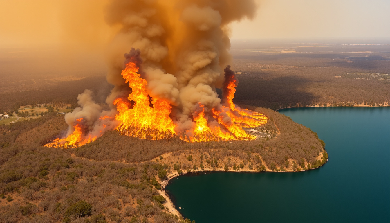
A bushfire at Enoggera Reservoir near Mount Nebo Road and Betts Road remained active under an ADVICE warning as of October 4, 2025, with authorities urging residents to stay informed and monitor official channels. The fire, which began on October 3, is burning in containment lines near Betts Road but continues to move toward Mount Nebo Road in Queensland’s north-west Brisbane region.
The incident occurred amid record heat across Queensland, which triggered more than 100 bushfires statewide. An exclusion zone was established by Queensland Police on October 3 covering Enoggera Reservoir and nearby Camp Mountain areas. While the fire was downgraded from Watch and Act to Advice by October 4, officials warn conditions could deteriorate rapidly and advise continued vigilance.
Firefighters remained on site managing the blaze, with smoke hazards affecting the Enoggera Reservoir area. Queensland Fire Emergency Services has provided regular updates through official channels, with the most recent ADVICE warning issued at 6:46pm on Saturday, October 4, 2025.
What is the current status of the Enoggera Reservoir fire?
Key insights
- The fire near Betts Road is burning in containment lines but heading toward Mount Nebo Road
- Warning was downgraded from Watch and Act to Advice by October 4
- Smoke hazards continue to affect the Enoggera Reservoir area
- Firefighters are actively responding to the incident
- Queensland Police established an exclusion zone on October 3
- Record heat across Queensland contributed to over 100 simultaneous bushfires
- Residents urged to stay informed and avoid smoke-affected areas
Snapshot of key facts
| Fact | Details |
|---|---|
| Warning Level | Advice / Watch and Act / Prepare to Leave (varied by date) |
| Affected Roads | Mount Nebo Road, Betts Road, Camp Mountain Road |
| Fire Origin | Enoggera Reservoir area, Brisbane north-west |
| Update Times | Continuous updates from October 3-7, 2025 |
| Conditions | Extreme heat contributing to fire risk |
| Containment Status | Burning in containment lines near Betts Road |
| Exclusion Zone | Established by QLD Police on October 3 |
| Active Firefighters | On site managing the blaze |
The fire remains dynamic. While downgraded to Advice, authorities warn conditions could change quickly. Smoke may affect visibility and air quality in surrounding areas. Residents should avoid the Enoggera Reservoir region until officials confirm it is safe.
Where is the Enoggera Reservoir fire located?
The bushfire is burning in the Enoggera Reservoir area, located in Brisbane’s north-west suburbs near the D’Aguilar Range. The fire affects multiple roads including Mount Nebo Road, Betts Road, and Camp Mountain Road in the Samford Valley region.
Affected road corridors
Mount Nebo Road runs between Camp Mountain Road and Scrub Road, passing through the bushland surrounding Enoggera Reservoir. Betts Road intersects this area and was among the first locations placed under evacuation warnings when the fire began. The intersection of these corridors created a significant concern for emergency responders.
Camp Mountain Road was also included in the exclusion zone issued by Queensland Police on October 3. This area forms part of a network of rural roads that wind through eucalypt forest and bushland, making them vulnerable to fire spread during extreme weather conditions.
Geographic context
Enoggera Reservoir sits within a forested catchment area managed by Seqwater. The reservoir and surrounding national park lands create a landscape where bushfires are a recurring risk, particularly during Queensland’s fire season. The area features steep terrain, dense vegetation, and limited access roads, complicating firefighting efforts.
If travelling in the Mount Nebo Road area, check road closure status before departing. Some routes may be restricted by emergency services. Alternate routes can be verified through Queensland Police traffic advisories.
How can I view the QLD fire map for Enoggera Reservoir?
The Queensland Fire Department provides interactive fire maps through its official website, allowing residents to track current incidents in real time. These maps show active fire locations, warning levels, road closures, and exclusion zones across Queensland.
Accessing official QLD fire maps
To view the Enoggera Reservoir fire on the official Queensland Fire map, visit Queensland Fire Department’s official website and use the interactive incident viewer. Users can search by address, local government area, or incident name to locate specific fires. The map updates continuously as conditions change.
The Queensland Fire Department website provides multiple tools for tracking bushfires. The incident lookup function allows searches for “Enoggera Reservoir” or “Mount Nebo” to find the relevant fire. Mobile users can access the same information through the responsive interface designed for smartphones and tablets.
Alternative map resources
Queensland Police published an exclusion zone map covering Enoggera Reservoir and Camp Mountain fires on October 3. This map detailed the specific areas where access was restricted. Additional mapping services may show smoke plumes and fire progression, though these should be cross-referenced with official sources.
Unofficial fire maps and social media images may not reflect current conditions. Always confirm information through official Queensland Fire Department channels before making safety decisions or sharing updates with others.
What fire restrictions are in place for South East Queensland?
Queensland operates a statewide fire restriction system that can escalate based on weather conditions. While no total fire ban specifically tied to southeast Queensland had been formally announced for October 2025 at the time of reporting, local fire bans and States of Fire Emergency can be declared when conditions warrant.
Understanding fire ban levels
Queensland’s fire ban system operates across several levels. Local Fire Bans apply to specific local government areas and prohibit all open fires, suspend fire permits, and restrict certain activities. A State of Fire Emergency represents the highest level of restriction, granting authorities broader powers to manage fire risk.
During fire bans, gas and electric barbecues are typically permitted while solid fuel fires are prohibited. However, restrictions can vary by area and weather conditions. Residents should verify current restrictions for their specific location rather than relying on general information.
Checking current restrictions
Fire restrictions apply to entire local government areas during high-risk weather and remain active until officially cancelled. The Queensland Fire Department advises residents to check restrictions using the interactive maps on fire.qld.gov.au or by contacting authorities directly.
For current fire ban information, residents can call the statewide freecall line at 1800 020 440 or contact the Caboolture/Brisbane area office at (07) 5420 3733. Official updates are published on fire.qld.gov.au and through Queensland Emergency Services channels.
Record heat across Queensland in early October 2025 contributed to more than 100 bushfires statewide. The extreme temperatures created conditions where fire risk elevated rapidly, prompting heightened vigilance and potential escalation of fire restrictions in affected regions.
Timeline of Enoggera Reservoir fire
The following timeline documents key events in the Enoggera Reservoir bushfire incident based on official sources and emergency service updates.
- October 3, 12:48pm: Queensland Fire Department issued a Prepare to Leave warning for Mount Nebo Road, Enoggera Reservoir area
- October 3, afternoon: Watch and Act alert issued near Betts Road as a slow-moving fire demonstrated active fire behaviour
- October 3, evening: Queensland Police established an exclusion zone covering Enoggera Reservoir and Camp Mountain fires
- October 4, morning: Over 100 bushfires burning across Queensland as record heat persisted
- October 4, 6:46pm: Warning downgraded to Advice for Mount Nebo Road, Betts Road, and Camp Mountain Road areas
- October 4, evening: Reports confirmed fire burning in containment lines near Betts Road, moving toward Mount Nebo Road
- October 7, 10:37am: Queensland Fire Department issued smoke advice for the Enoggera Reservoir area
- October 7, 3:30pm: Latest available update indicated continued burning in containment lines
Current status and uncertainties
Understanding what is confirmed and what remains unclear helps residents make informed decisions during evolving fire emergencies.
| Established information | Remaining uncertainties |
|---|---|
| Fire began October 3, 2025 | Precise ignition point within the Enoggera Reservoir area |
| Burning in containment lines near Betts Road | Exact containment percentage achieved |
| Warning level downgraded to Advice | Whether conditions will escalate again |
| Smoke affecting the area | Duration of smoke impacts |
| Firefighters on site | Number of personnel deployed |
| Exclusion zone in place | When exclusion zone may be lifted |
Fire conditions remain dynamic. While containment lines are holding near Betts Road, the fire continues to move toward Mount Nebo Road. Authorities advise monitoring official channels for real-time certainty. No full containment has been officially confirmed as of the latest available updates.
Background and context
The Enoggera Reservoir bushfire represents a significant incident within a broader pattern of fire activity across Queensland. Record heat in early October 2025 created conditions that triggered more than 100 bushfires across the state, placing emergency services under considerable pressure.
Enoggera Reservoir sits within a forested catchment area that experiences periodic fire activity during Queensland’s bushfire season. The combination of steep terrain, dense eucalypt forest, and limited access routes creates challenges for both firefighting operations and community evacuation.
Firefighters have been actively managing the incident while simultaneously responding to numerous other fires statewide. The extreme heat event that preceded the fire activity created conditions where multiple simultaneous incidents became likely, testing the capacity of Queensland’s fire emergency response systems.
Official updates and sources
The following sources have provided verified information about the Enoggera Reservoir fire. All residents should monitor official channels for the most current updates.
“The fire near Betts Road is now burning in containment lines.”
— ABC Emergency coverage, October 2025
“PREPARE TO LEAVE – Enoggera Reservoir area.”
— Queensland Fire Department, X (formerly Twitter) post, October 3, 2025
“Watch and Act alert downgraded to Advice for the Enoggera Reservoir fire.”
— 9News Queensland, October 4, 2025
For the most current information, residents should consult Queensland Fire Department’s official website, ABC Emergency coverage, and official social media channels including the Queensland Fire Department Facebook page and QLD Fire Department on X.
What’s next and safety advice
Residents in and around the Enoggera Reservoir area should continue monitoring official channels as conditions develop. Even with the downgrade to Advice warning, the fire remains active and conditions can change rapidly.
Recommended safety actions
- Monitor fire.qld.gov.au for regular updates
- Avoid smoke-affected areas around Enoggera Reservoir
- Check the Queensland fire ban map for current restrictions
- Report new fire sightings to Triple Zero (000) for emergencies
- Keep emergency contact numbers readily available
- Have evacuation plans prepared if conditions escalate
For further reading on emergency preparedness, see our guide to Brisbane Broncos Players 2024 emergency response protocols.
Frequently asked questions
What is the latest update on the Enoggera Reservoir fire?
As of October 4, 2025, the fire was under an ADVICE warning, downgraded from Watch and Act. Firefighters were managing the blaze in containment lines near Betts Road, with smoke affecting the area. Continued monitoring is advised.
Where exactly is Mount Nebo Road located?
Mount Nebo Road runs through the Samford Valley area west of Brisbane, connecting Camp Mountain Road and Scrub Road. It passes near Enoggera Reservoir and was included in the fire warning area.
How do I access the Queensland fire map?
Visit fire.qld.gov.au and use the interactive incident viewer. Search by location name or address to find the Enoggera Reservoir fire and view current warning boundaries.
Is there a total fire ban in southeast Queensland?
No specific total fire ban had been formally announced for southeast Queensland at the time of reporting. However, local fire bans can be issued quickly when conditions warrant. Check fire.qld.gov.au for current restrictions.
What roads are affected by the fire?
Mount Nebo Road, Betts Road, and Camp Mountain Road are all within the affected area. An exclusion zone established by Queensland Police restricts access to these corridors.
What should I do if I smell smoke?
If you smell smoke, stay indoors with windows closed and monitor official channels for updates. Those with respiratory conditions should follow medical advice and consider relocating if symptoms worsen.
How can I get emergency updates?
Call 1800 020 440 for statewide fire information or (07) 5420 3733 for the Brisbane/Caboolture area. Subscribe to Queensland Fire Department social media channels for push notifications.
Has the fire been contained?
The fire is burning in containment lines near Betts Road, but full containment has not been officially confirmed. Conditions remain dynamic and residents should continue monitoring for updates.
Related stories


Liam O'Brien covers Australian politics and public affairs for Australia Voice.